

Your phone knows where you are because it knows what time it is.
Every GPS fix starts with a clock. Each satellite carries an atomic clock, and your phone measures how long each satellite signal took to reach it. Time becomes distance, and four distances become a position. Open a map on a phone with no signal bars, no Wi-Fi, and no SIM card, and the blue dot still appears, and it moves as you walk.
GPS is the Global Positioning System, the American satellite navigation system run by the United States Space Force. Satellites broadcast, receivers only listen. Your phone sends nothing to space. That one-way design is why billions of receivers can use the same satellites at once, and why the system works with the phone offline.
Judge a GPS claim by its timing. A receiver with twelve satellites and a sloppy clock is worse than a receiver with four satellites and tight timing. Every number in the system traces back to a clock, and the rest of the article follows that chain.
Three parts run the system. The space segment is the constellation: at least 24 operational satellites in six orbital planes, tilted 55 degrees to the equator, circling at 20,200 kilometers and completing an orbit in 11 hours and 58 minutes. The control segment is the ground stations that track each satellite, measure its clock drift, and upload corrections. The user segment is every receiver on Earth. The United States Coast Guard Navigation Center publishes the live constellation status, and it listed 32 operational satellites on 13 September 2026.
Does GPS track me? No. A GPS receiver is a listener. It measures signals that rain down from orbit and computes its own position inside the phone. No record of that position leaves the device through GPS itself. An app can send your location over the internet afterward, and how the internet finds your device explains the addressing that carries it, but that is a phone and software decision. The satellites never learn where you are.
The satellites above your head carry more than timing. Satellite internet uses spacecraft for data, while GPS uses them for time. The two jobs share the sky and almost nothing else.
What rides on the signal?
A GPS signal carries three things: a code, a navigation message, and the carrier wave itself. The code is a repeating pattern unique to each satellite. The navigation message gives the satellite’s orbit data, clock corrections, and health. The carrier is the radio wave that carries both.
Civilian receivers use the L1 signal at 1,575.42 MHz. Newer receivers add L2 at 1,227.60 MHz and L5 at 1,176.45 MHz, and comparing two frequencies lets a receiver measure how much the ionosphere slowed the signal. The civilian code is a 1,023-bit Gold code, transmitted at 1.023 million bits per second and repeating every millisecond. Each chip in that code spans 293.05 meters of signal travel, and the L1 wave itself is 19.03 centimeters long.
The signal arrives faint. By the time it crosses 20,000 kilometers, its power at the antenna is about -130 dBm, near 0.1 femtowatts, below the background radio noise. A receiver finds it because it knows the exact code to search for. It generates a local copy of the satellite’s code and slides that copy in time until the two line up. The offset between them is the travel time. Correlation pulls a known pattern out of noise that would swamp any ordinary broadcast.
At 50 bits per second, the navigation message travels slowly. One frame takes 30 seconds. The full almanac, the rough orbit data for the whole constellation, takes 12.5 minutes to arrive. That slow trickle is the reason a receiver that has been off for weeks takes a while to find itself, and it is the reason assisted GPS exists.
All satellites share the same frequencies. They stay separable because each one broadcasts a different code, a technique called code division multiple access. A receiver sorts dozens of overlapping signals by matching each code in turn. The lookup idea is not unique to GPS: how DNS finds websites is the same pattern in the other direction, a name resolved to an address, while GPS resolves signal delays to coordinates.
The fix, worked out with real numbers
Four distances become a position through trilateration. One distance puts the receiver somewhere on a sphere around a satellite. A second distance narrows that to a circle where two spheres cross. A third narrows it to two points. A fourth resolves the receiver’s clock error. Triangulation measures angles. GPS measures distances.
Equations state the method. A solved fix proves it, so a fix was computed on 12 November 2026. A least-squares solver ran on four chosen pseudoranges for a receiver at Times Square, New York, at 40.7580 north, 73.9855 west, 10 meters above sea level. The four satellites sit at 20,200 kilometers altitude, spread across the sky. The receiver clock was set 1.2 ms ahead of GPS time, a typical cheap quartz error. The model uses a spherical Earth, which real receivers replace with the WGS84 ellipsoid; the difference shifts the answer by meters. The point of the example is unchanged.
| Satellite (azimuth, elevation) | True range | Signal travel time | Pseudorange |
|---|---|---|---|
| Satellite 1 (40°, 55°) | 21,099.69 km | 70.38 ms | 21,459.44 km |
| Satellite 2 (140°, 35°) | 22,399.18 km | 74.72 ms | 22,758.93 km |
| Satellite 3 (230°, 65°) | 20,660.13 km | 68.91 ms | 21,019.88 km |
| Satellite 4 (320°, 25°) | 23,243.53 km | 77.53 ms | 23,603.28 km |
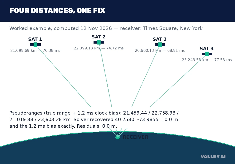
The solver recovered 40.7580 north, 73.9855 west, 10.0 meters, and a clock bias of 1.2 milliseconds. Every residual was 0.0 meters. That exact recovery shows the equations close on clean inputs, and it is not a claim about field accuracy. Real ranges carry noise, and the same solver shows what noise does.
With plus or minus 10 meters of noise added to the four pseudoranges, the same solver landed 7.27 meters off horizontally and 8.07 meters off vertically. The error grew from the noise, and the geometry decided how much. With the same noise but all four satellites bunched into one quadrant of the sky, the error jumped to 222.99 meters horizontally and 114.69 meters vertically. Same solver, same clock bias, same noise. Only the sky geometry changed, and the error grew thirtyfold. That magnification is what dilution of precision measures.
Each distance works like a rope of known length tied to a point in the sky. One rope leaves you anywhere on a sphere. Two ropes leave a circle. Three leave two points. Four ropes, with one of them absorbing the clock error, leave a single point on Earth. The ropes are radio travel times, and the knots are nanoseconds.
Why the fix needs a fourth satellite?
Three distances can locate a point in three dimensions on paper. Real receivers need a fourth satellite because their clocks are cheap quartz. They are not atomic clocks synchronized to GPS time. A phone clock can sit milliseconds away from GPS time, and a millisecond of error is 359.75 kilometers of range error. The fourth measurement gives the receiver a fourth unknown to solve for: its own clock bias.
Drop to three satellites and the fix falls apart. With only three pseudoranges for four unknowns, the solver returns numbers, but they are meaningless: one starting guess landed at 48.08 north, 131.41 west, 3,856,152 meters below sea level, with a clock bias of -12.07 milliseconds. Other starting guesses landed in other absurd places. Three equations cannot pin four unknowns, and no amount of precision in the three measurements fixes that.
More satellites help beyond the fourth. With five, eight, or twelve in view, a receiver can reject a bad measurement, average down the noise, and pick the spread that gives the strongest geometry. The count matters, but only through the geometry and the clock. A dozen satellites bunched together in one patch of sky still give a weak fix.
Altitude stays the weakest number. Every satellite sits above the receiver, never below it, so the vertical geometry is lopsided where the horizontal geometry is balanced. Phones combine GPS with a barometer, inertial sensors, or map data when height matters.
Einstein is in the loop
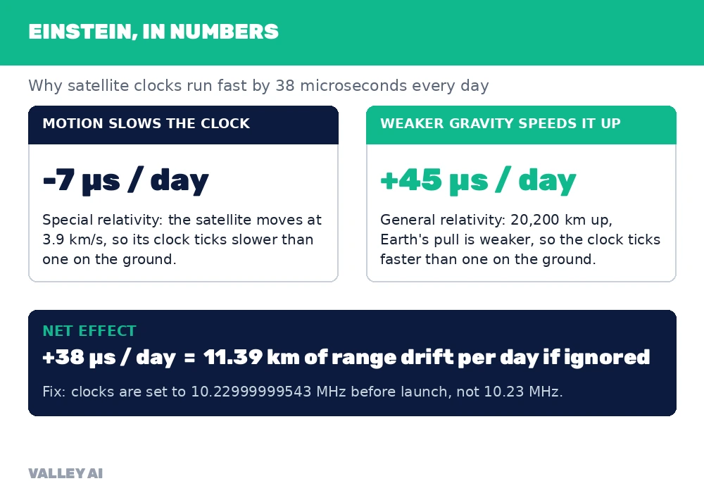
GPS would fail within a day if relativity were ignored. Satellite clocks run fast by a net 38 microseconds per day compared with clocks on the ground. Multiply that by the speed of light and the range error grows 11.39 kilometers every day. The system was built with the correction inside it from the start.
Two effects add to that net figure. Motion slows the satellite clocks by about 7 microseconds per day, because the satellites move at 3.9 kilometers per second relative to the center of the Earth. Weaker gravity speeds them up by about 45 microseconds per day, because they orbit 20,200 kilometers up, where Earth’s pull is weaker. The two numbers combine to plus 38 microseconds per day.
Engineers correct the larger part before launch. Each satellite clock is set to run slightly slow, at 10.22999999543 MHz instead of the nominal 10.23 MHz, so it ticks at the right rate once in orbit. Orbits are not perfect circles, so speed and altitude vary slightly through each pass. Receivers calculate that periodic correction from the satellite’s precise orbit; it reaches about 45 nanoseconds, near 13.5 meters of range.
The scale of the problem is what makes atomic clocks mandatory. Light travels about 30 centimeters in one nanosecond. A clock error of 10 nanoseconds is 3.0 meters of range error, and a civilian fix needs timing near 10 to 15 nanoseconds. A cesium clock counts 9,192,631,770 oscillations per second by definition, and a rubidium clock runs near 6,834,682,611 Hz. Each satellite carries several of them, and the United States Naval Observatory holds the master clock the whole system is steered to.
What pushes the blue dot off?
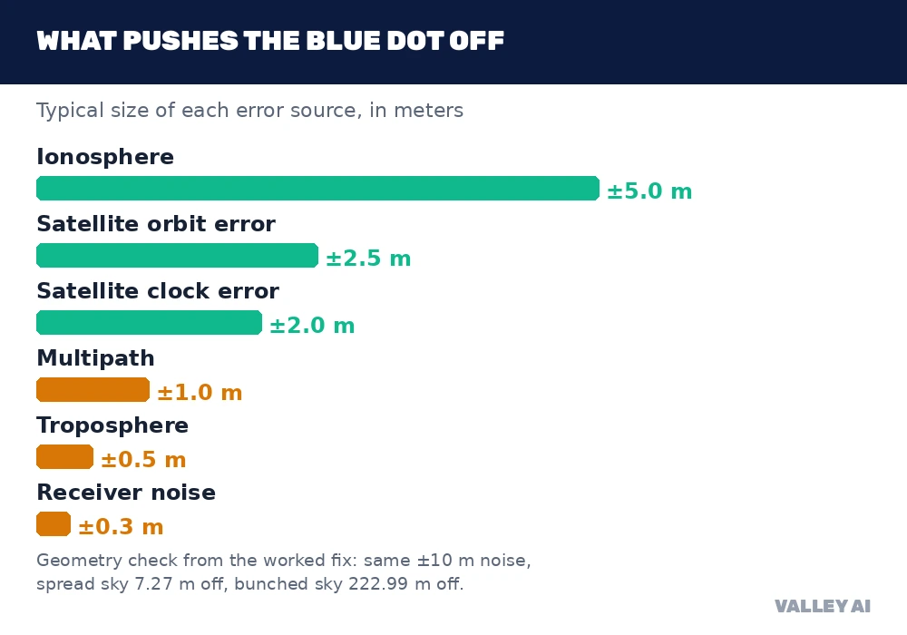
A phone under open sky typically lands within a 4.9 meter radius, according to GPS.gov, which cites the Institute of Navigation. The government commits to broadcasting the signal itself with a user range error of 2.0 meters or less, 95 percent of the time, and measured 0.643 meters on 20 April 2021. The gap between the signal in space and the dot on your screen is local error, and the table below lists the usual suspects.
| Error source | Typical size | What it is |
|---|---|---|
| Ionosphere | Plus or minus 5 m | Charged upper air slows the signal; varies with frequency and solar activity |
| Satellite orbit error | Plus or minus 2.5 m | The broadcast orbit differs slightly from the true orbit |
| Satellite clock error | Plus or minus 2 m | Residual drift after ground corrections |
| Multipath | Plus or minus 1 m | The signal bounces off glass, metal, or rock and arrives late |
| Troposphere | Plus or minus 0.5 m | Water vapor and air pressure delay the lower-air path |
| Receiver noise | Plus or minus 0.3 m | Antenna quality and processing limits |
Multipath is the error a city reader feels most. A signal that bounces off a glass tower travels a longer path than the direct one, so the receiver measures a late arrival and places the dot across the street. A search engine ranks nearby places from the same fix, so a multipath error moves the wrong shop to the top of the list. Tall buildings block satellites outright, which leaves fewer signals and worse geometry in exactly the places where the map matters most.
Why is altitude always worse? Satellites only ever appear above the horizon, so the vertical measurement leans on one-sided geometry. Horizontal position draws on satellites spread around the compass; height draws on satellites stacked above. Receivers report the split as separate dilution values, and a position dilution of 2 counts as good while values above 6 count as poor.
Correction systems close most of the gap. The Wide Area Augmentation System broadcasts corrections from geostationary satellites and brings typical accuracy to 1 to 3 meters. Real-time kinematic positioning uses a base station at a known spot and carrier-phase measurements to reach centimeters. Precise point positioning needs no local base station and reaches decimeters, at the cost of 20 to 30 minutes of convergence.
Why your phone finds you in seconds?
A receiver that has been off for weeks faces a cold start. It must find the satellites, read the 50-bit-per-second navigation message, and collect the almanac before it can compute anything. That takes tens of seconds, and the full almanac takes 12.5 minutes. A phone skips most of that wait with assisted GPS. The cellular or Wi-Fi network hands the phone the orbit data, the time, and a rough starting position, so the receiver locks in seconds. Wi-Fi positioning gives the same rough start from nearby networks. Assistance speeds the fix; the measurement itself still comes from the satellites.
Why does my phone still know where I am in a tunnel? It does not. No GPS signal reaches through rock and concrete, so the receiver loses its satellites underground. The phone keeps the dot moving with dead reckoning: the accelerometer and gyroscope track each turn and each change of speed from the last known fix, and the map software snaps the result to the road. Reacquiring the sky at the tunnel exit corrects the drift.
Three checks tell you whether to trust a fix, and they take seconds in any GPS status app. First, count the satellites in view: four is the minimum, eight or more spread across the sky is a healthy fix. Second, read the signal strength for each one: a strong satellite sits well above the noise, a weak one is fighting buildings or foliage. Third, read the dilution of precision: a position dilution near 2 is good, above 6 is poor. A fix that passes all three is worth trusting. A fix that fails the third, even with plenty of satellites, is a bunched-sky fix, and the worked numbers put that kind of error in the hundreds of meters. When the checks fail, wait for the sky to open, step away from the glass tower, and let the receiver gather a better spread. The satellites will still be there, broadcasting the time.
Frequently asked questions
Why does GPS drain the battery so fast?
A GPS fix is continuous work. The receiver listens to faint satellite signals, correlates codes, and solves the position equations about once per second, and the screen-on map on top of it draws power too. The drain grows when the sky is blocked, because the receiver works harder to hold weak signals. Turning location off for apps that do not need it, and using battery-saver location modes, cuts the work without losing the fix when you do need it.
Is GPS free to use?
Yes. The United States government provides the GPS signal free of charge to anyone, anywhere, with no subscription and no account. The cost sits in the device and its apps: a phone, a receiver chip, and any map data the app downloads over a mobile or Wi-Fi connection. The positioning itself costs nothing.
How accurate is GPS for measuring speed?
GPS measures speed from the Doppler shift of the satellite signals and from position change over time. The government commits to a signal-in-space range-rate error of 0.006 meters per second or less over any three-second interval, 95 percent of the time. A phone under open sky tracks speed closely at that level. The same blockages that hurt position hurt speed: tunnels, car parks, and urban canyons make readings jump.
Does GPS work on an airplane?
Yes, at cruising altitude the sky view is clear and the receiver locks quickly. Airplane mode switches off the radios, but location can stay on, and a phone in airplane mode with location enabled still gets a fix. The map itself may stay blank unless its tiles were downloaded before the flight, because the map data travels over the internet and the positioning does not.
What happens to GPS during a solar storm?
A major solar storm disturbs the ionosphere, which is the layer that already causes the largest single GPS error. Signals slow unevenly, accuracy degrades, and receivers can briefly lose lock. GPS.gov lists major solar storms among the rare causes of wrong positions, next to jamming and satellite maintenance. Ordinary space weather stays inside the system’s error budget, and the effect passes with the storm.

Kaleem
Kaleem is a Computer Science graduate (Virtual University of Pakistan) and the founder and editor of Valley AI, where he publishes in-depth, tested guides on computer hardware, artificial intelligence, and how the internet works. Every guide is researched from primary sources, tested hands-on where possible, and updated when the facts change.